Log in
All resources
Create a design
4,774 Free Images of Atlas Map
joan blaeu
maps of paris from the david rumsey historical map collection
david rumsey historical map collection
maps with figures
copper engraving print
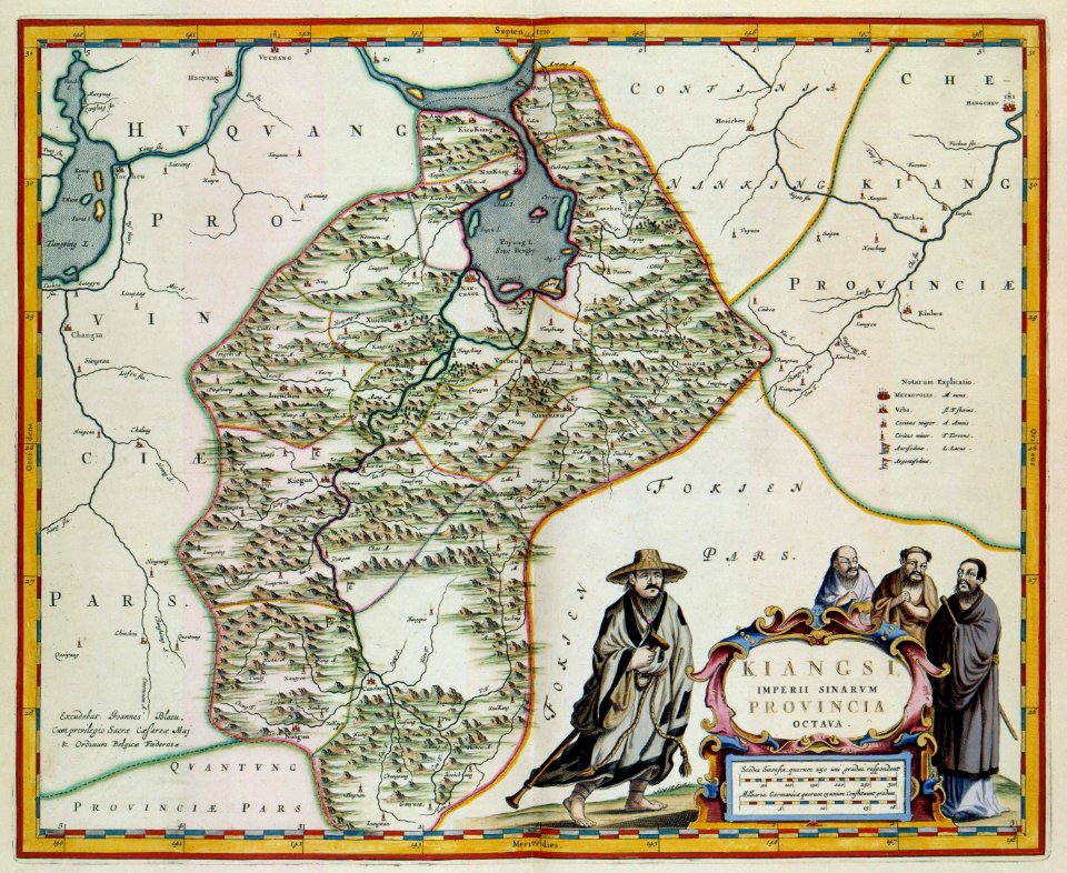
novus atlas sinensis
maps with cartouches
atlas des anciens plans de paris by imprimerie nationale, 1900 from the david rumsey historical map collection
atlas novus (blaeu)
british library
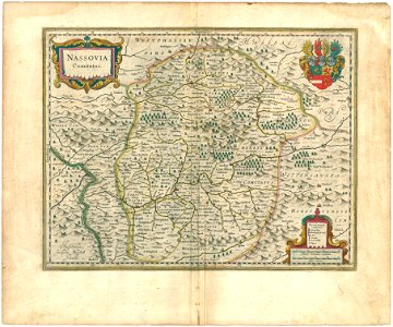
old maps of the duchy of jülich
maps of the duchy of berg
maps of paris from the david rumsey historical map collection
proletarian literature
media from atlas of mutual heritage on dutch east india company
1665
russian empire in thomas kitchen's general atlas (1773)
general atlas (1773)
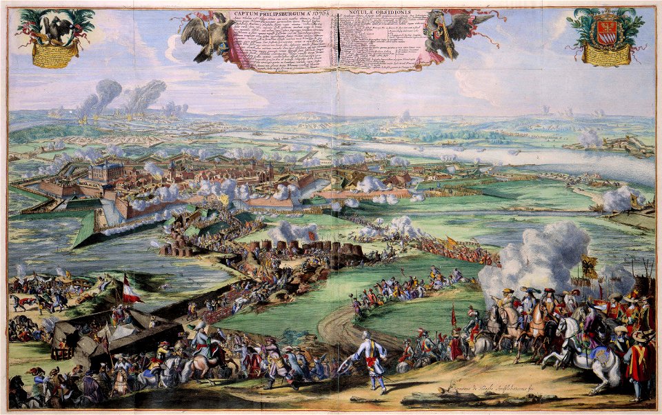
siege of gravelines (1644)
atlas van loon
maps from university of amsterdam special collections
atlas der neederlanden
atlas maior, vol 11 (asia) - joan blaeu, 1667 - bl 114.h(star).11
1667 maps
russian empire in thomas kitchen's general atlas (1773)
general atlas (1773)
atlas van der hagen (volume 4)
atlas van der hagen
atlas van der hagen (volume 4)
atlas van der hagen
maps by john cary
1806 maps of asia
1660s maps of belgium
old maps of bruges
atlas sive cosmographicae (gerardus mercator, 1596)
gerardus mercator
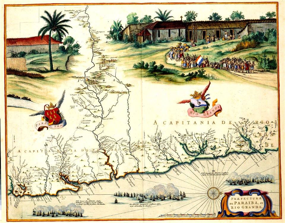
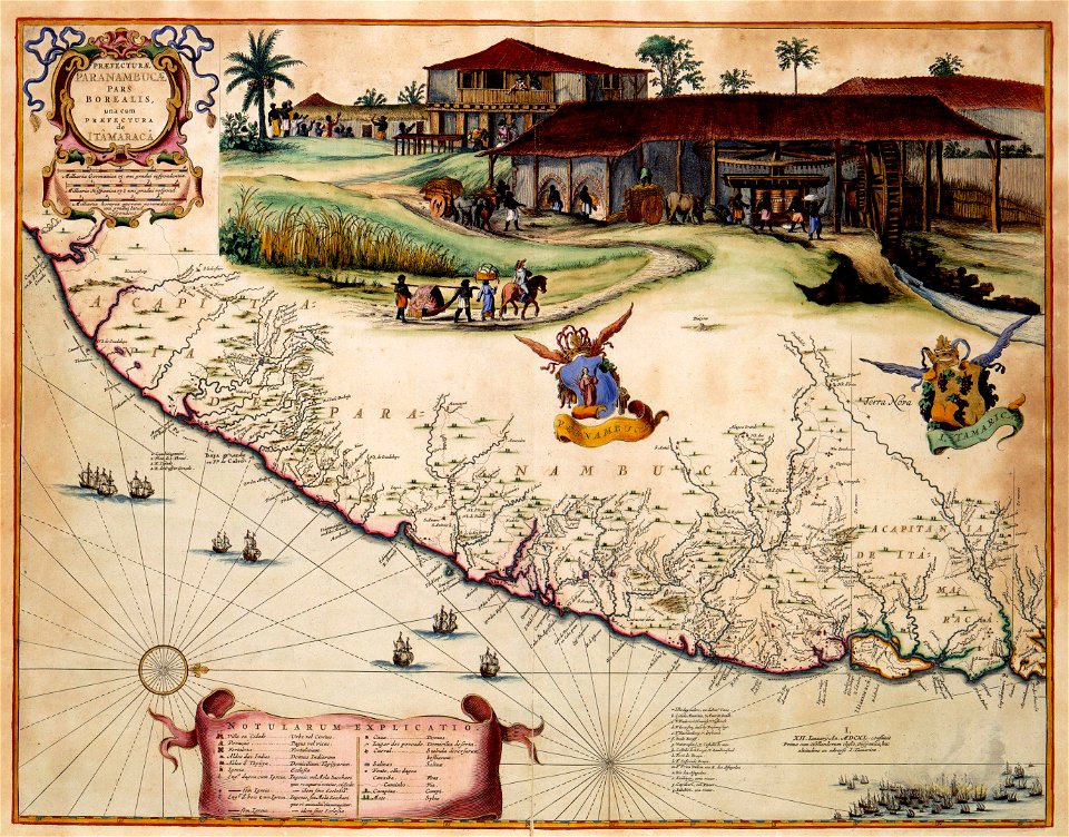
maps of colonial brazil
1510s maps of brazil
atlas maior, vol 11 (asia) - joan blaeu, 1667 - bl 114.h(star).11
1667 maps
atlas maior, vol 1 (northern europe, norway, and denmark) - joan blaeu, 1667 - bl 114.h(star).1
1667 maps
compass roses on maps
compasses in spain
old maps of north rhine-westphalia
maps of rietberg
coats of arms on maps
house of nassau
old maps of the new kingdom of granada
17th-century maps of guyana
maps made in the 17th century
siege of groenlo
maps by willem and johannes blaeu
siege of breda 1637
17th-century maps of lower saxony
atlas novus (blaeu)
17th-century maps of hungary
old maps of hont county
historical coats of arms of denmark
ships on maps
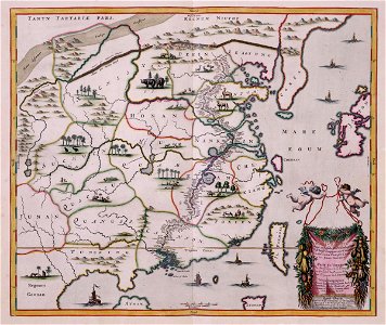
old maps of zhejiang
maps with cartouches
1645 maps of belgium
tournaisis
atlas van der hagen (volume 4)
people with animals in art
illuminated manuscripts in the museo correr
pietro vesconte
atlas ou representation du monde universel t. 2 (1633)
maps by jan janssonius
maps of paris from the david rumsey historical map collection
map of paris by jouvin de rochefort (boutier 133)
1810s maps of the iberian peninsula
maps of spain by tomas lopez
atlas van der hagen (volume 4)
atlas van der hagen
colonial history of the united states
old maps of new york (state)
old maps of cádiz
1664 maps
maps by john cary
1799 maps
atlas maior, vol 11 (asia) - joan blaeu, 1667 - bl 114.h(star).11
1667 maps
atlas maior, vol 11 (asia) - joan blaeu, 1667 - bl 114.h(star).11
1667 maps
atlas maior, vol 11 (asia) - joan blaeu, 1667 - bl 114.h(star).11
1667 maps
maps from university of amsterdam special collections
atlas der neederlanden
maps in the library of congress
novus atlas sinensis
maps of the dutch east india company - china
1665
1660s maps of spain
1667 maps
17th-century maps of the strait of magellan
1635 maps
18th-century maps of china
18th-century maps of asia
maps of nieuw nederland
nicolaes visscher ii
maps of the hague by braun & hogenberg
atlas van loon
atlas van der hagen (volume 3)
atlas van der hagen
maps in the library of congress
old maps of yunnan
petit atlas pittoresque des 48 quartiers de la ville de paris, david rumsey historical map collection
maps of paris from the david rumsey historical map collection
atlas maior, vol 1 (northern europe, norway, and denmark) - joan blaeu, 1667 - bl 114.h(star).1
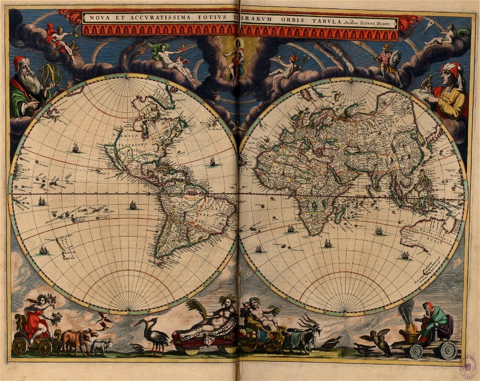
17th-century double hemisphere world maps
maps by christian sgrothen
inde (river)
1650s maps of the world
age of discovery
monomotapa
mutapa
maps by thomas kitchin
andrew dury
miniature speed atlas (1627) pieter van den keere
old county maps of anglesey
maps from university of amsterdam special collections
atlas der neederlanden
gemeente atlas van nederland - south holland
hugo suringar
maps of the west-indische compagnie
old maps of dutch brazil
maps by willem and johannes blaeu
old maps of upper lusatia
atlas van der hagen (volume 4)
1660s maps of pernambuco
petit atlas pittoresque des 48 quartiers de la ville de paris, david rumsey historical map collection
maps of paris from the david rumsey historical map collection
old maps of utrecht (city)
atlas van loon
historic views of erkelenz
maps by christian sgrothen
17th-century maps of andalusia
old maps of the alboran sea
atlas des anciens plans de paris by imprimerie nationale, 1900 from the david rumsey historical map collection
maps of paris from the david rumsey historical map collection
atlas des anciens plans de paris by imprimerie nationale, 1900 from the david rumsey historical map collection
maps of paris from the david rumsey historical map collection
atlas des anciens plans de paris by imprimerie nationale, 1900 from the david rumsey historical map collection
maps of paris from the david rumsey historical map collection
atlas des anciens plans de paris by imprimerie nationale, 1900 from the david rumsey historical map collection
maps of paris from the david rumsey historical map collection
atlas des anciens plans de paris by imprimerie nationale, 1900 from the david rumsey historical map collection
maps of paris from the david rumsey historical map collection
atlas des anciens plans de paris by imprimerie nationale, 1900 from the david rumsey historical map collection
maps of paris from the david rumsey historical map collection
maps with cartouches
old maps of yunnan
maps of hulsterse bolwerken
old maps of hulst
maps of valenciennes by braun & hogenberg
maps of valenciennes city walls
pacific ocean in art
ships on maps
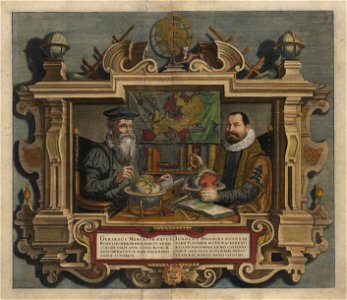
gerardus mercator
jodocus hondius
maps from university of amsterdam special collections
atlas der neederlanden
17th-century maps of the strait of magellan
maps by nicolas sanson
novus atlas sinensis
lotus in art
17th-century double hemisphere world maps
nuevo atlas o teatro mundo
maps by willem and johannes blaeu
maps of the county of nice
maps of paris from the david rumsey historical map collection
baroque
maps of paris from the david rumsey historical map collection
baroque
atlas schoemaker-noord-holland, amsterdam
old maps of amsterdam
maps of the palatinate of the rhine
maps by willem and johannes blaeu
old maps of the eastern mediterranean
catalan atlas
hildesheim see coat of arms
coats of arms on maps
old maps of the sea of marmara
catalan atlas
maps from university of amsterdam special collections
atlas der neederlanden
atlas des anciens plans de paris by imprimerie nationale, 1900 from the david rumsey historical map collection
maps of paris from the david rumsey historical map collection
atlas maior, vol 5 (england) - joan blaeu, 1667 - bl 114.h(star).5
old county maps of pembrokeshire
atlas van der hagen (volume 1)
atlas van der hagen
novus atlas sinensis
old maps of hunan
russian empire in thomas kitchen's general atlas (1773)
general atlas (1773)
old maps of kreis kleve
history of geldern
maps of paris from the david rumsey historical map collection
baroque
maps of paris from the david rumsey historical map collection
baroque
atlas van loon
1664 maps
maps by john cary
1799 maps
maps of paris from the david rumsey historical map collection
romanticism
101 - 200 of 4,774
Next page
/ 48